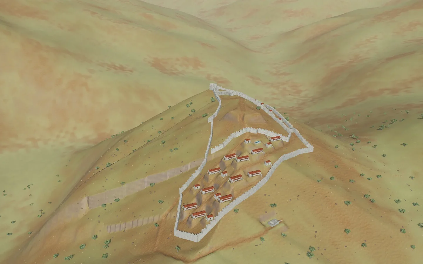
01The acropolis
Ancient acropolis · proposed 4th–2nd centuries BCE
The hill above modern Borsh commanded the coastal route and a branch leading inland along the Çorraj valley. The ancient name of the settlement is uncertain: Borsh is the modern place-name used for this reconstruction.
Jano Koçi’s 1977 study distinguishes the acropolis, the lower city and a further ancient extension. He records an acropolis of about 1.2 hectares, with a wall circuit of about 500 metres, extending towards a northeastern crest and rectangular tower. The acropolis must not be reduced to the outline of the smaller medieval castle seen in today’s photographs.
The separate Ancient Borsh study proposes a 4th–2nd-century BCE interpretation. The site had earlier occupation and a long later history; that ancient study does not represent every period simultaneously. The published plan and project drone photographs guide the hilltop relationships. They do not establish a metrically registered survey: reconstructed levels, paths, complete wall heights and individual building positions remain interpretations.
Jano Koçi, “Qyteti antik i Borshit”, 1977, pp. 269–270 and plate I · Kriledjan Çipa, 2018, discussion of the settlement and its name, pp. 100–101
02The ancient walls
Ancient fortifications · successive phases from the 4th century BCE
The ancient defences use the hill’s ridges and exposed rock. Koçi reports a well-preserved southwestern stretch 60 metres long, surviving to a maximum height of 4 metres. Those are dimensions of the surviving section, not proof of the original height of every wall.
Much of the circuit used bulging-faced trapezoidal blocks in irregularly interrupted horizontal courses, recorded at 0.30–0.70 metres high. A later ancient extension used more regular rectangular masonry, with courses around 0.50 metres high. These distinct treatments guide the reconstruction; repeated blocks in the model are authored approximations rather than a catalogue of surveyed stones.
Koçi gives 2.5 hectares for the city together with the acropolis, and approximately 3 hectares including its extension. The approximately 1,000-metre wall length belongs to his description of the ancient city circuit. These archaeological totals are distinct from the extent of the medieval fortress and from any measured area claimed for this draft model.
The publication proposes successive construction phases from the 4th century BCE, followed by expansion and repairs. Complete upper courses, defensive crest, missing stretches and terrain contacts remain proposed. The ancient lower city’s angular wall line should not be understood as a ring of medieval towers.
Jano Koçi, 1977, pp. 269–270, plate I and wall photographs · Kriledjan Çipa, 2018, masonry discussion, p. 101
03The eastern corridor gate
Ancient lower-city entrance · Hellenistic interpretation
On the eastern side, Koçi identifies an entrance at point F of the published plan. The passage runs parallel to the wall, giving this approach a different form from a simple opening through the face of the defences.
The same study separately locates the acropolis entrance at the position later used by the medieval castle. It also describes a stepped entrance protected by a small tower in the ancient extension. These are distinct features; the modeled eastern gate does not reproduce the surviving medieval entrance or combine all three into a single gateway.
The source establishes the eastern gate’s corridor arrangement but supplies no measured passage width used here. Its restored width, lintel or roof treatment, doors, complete wall heights and approach path are proposed to make the documented arrangement intelligible and explorable. The current terrain and photographs cannot independently recover all these lost details.
Jano Koçi, 1977, pp. 269–270 and plate I, point F
04The rock-cut houses
Terraced houses · Hellenistic phases; later reuse kept separate
Borsh’s houses adapted to the steep southwestern and eastern slopes. Excavation reports describe rock-cut floors and wall faces, stone retaining terraces, compacted clay floors and tiled roofs. These source-specific features guide the housing instead of a regular, flat street grid.
Koçi’s 1986 report records an upper part of a two-level house measuring 13 × 4.30 metres, reached by five rock-cut steps. A corridor served rooms to the east. The northern rock face rose 2.20 metres, with a ledge interpreted as support for roof beams. Large worked stones and smaller mud-bonded partition stones had different structural roles.
The 1989 report describes a 1.50 × 10-metre veranda with stone supports at 5-metre intervals. It also records a separate eastern room measuring 5 × 4 metres, with 0.70-metre walls, a 0.80-metre southern doorway and a natural rock face up to 3 metres high. These measurements describe particular excavated structures, not every house in the city.
The model uses the reports as dimensional and construction references. House locations, repeated examples, complete storeys, roofs, furnishings, terraces and connecting paths remain proposed. The medieval lime plaster and bench described in the reused eastern room are kept out of this ancient interpretation. Tiles support a tiled-roof reconstruction, but exact roof pitches and timber joints are not recovered evidence.
Jano Koçi, 1986 excavation report, pp. 261–262 · Jano Koçi, 1989 excavation report, p. 273 · Kriledjan Çipa, 2018, house architecture, p. 101
05The proposed communal cistern
Communal water storage · proposed ancient interpretation
Water storage was essential for a settlement on a steep fortified hill. Kriledjan Çipa’s discussion of Borsh’s domestic architecture describes communal public water tanks, contrasting them with the individual wells or tanks known in houses at other sites.
That statement does not supply a plan, dimensions, exact location or detailed construction method for the cistern shown in this scene. Its entire modeled form and placement are proposed. The lining, walls, cover and access illustrate a possible shared water-storage installation; they do not reproduce a verified excavated monument.
The cistern is therefore labelled as a proposed interpretation, with lower confidence than the surviving fortification masonry or the measured house examples. It should not be used as evidence for the ancient city’s exact water network or capacity.
Kriledjan Çipa, 2018, “Architecture of houses”, p. 101
06The southern necropolis
Monumental tomb · proposed after the mid-3rd century BCE
Jano Koçi’s necropolis study records a monumental tomb on the southern slope, 30 metres below the enclosing wall, beside a route towards the city. Its outer construction measured 9.40 × 6 metres and was cut into the ground on three sides. The model follows the published dimensional reference, but its placement against the reconstructed city is approximate, not a surveyed archaeological coordinate.
The entrance lies to the east. A 1.20-metre-wide corridor leads down seven stone steps to the burial chamber, which measures 2.84 × 2.84 metres. The report’s stair dimensions contain a discrepancy: it states seven steps with 0.30-metre treads and rises, but also gives a 1.80-metre stair run and a 0.90-metre landing. The draft retains the documented stair count without claiming all these measurements form a resolved construction drawing.
Koçi proposes a date after the middle of the 3rd century BCE through architectural comparison. The reconstruction’s complete upper masonry, covering and landscape setting remain interpretations. The study also records simple graves from different periods; it does not justify treating every burial outside the walls as Hellenistic or repeating this monumental design across the cemetery.
Jano Koçi, “Varreza e qytetit antik në Borsh”, 1987, pp. 135–139, fig. 3
07Later Sopot
Later Sopot · medieval and Ottoman history; contextual note
The modern drone photographs show a hill changed by many centuries of reuse. The standing castle walls and domed mosque are not a complete surviving image of the Hellenistic city. Their medieval and Ottoman phases require a separate reading.
Nevila Molla’s archaeological study discusses Sopot’s medieval and Ottoman development. Written references place Sopot in the 13th century, and the fortress underwent several later alterations. Its smaller summit enclosures must not be confused with the larger ancient acropolis and lower city described by Koçi.
This marker is a historical context point. The separate Ancient Borsh study follows the proposed 4th–2nd-century BCE setting. The earlier castle is explored in Medieval Sopot, while Borsh across time brings ancient, medieval and Ottoman structures together with their periods identified. The images help identify the hill and surviving remains; the composite does not claim that buildings from different dates all stood together in antiquity.
Nevila Molla, “Archonteia Sopotu: Chronology and Function of a Byzantine Tower at the Fortress of Sopot”, 2012, pp. 253–256