Borsh across time · ancient, medieval and Ottoman eras combined
Ancient, medieval and Ottoman structures are shown together. This reconstruction spans different eras; it does not represent one historical date. Building labels identify each period and its reconstruction confidence. A proposed church is a hypothesis, not an identified archaeological building.
Ancient Borsh · proposed Hellenistic interpretation, 4th–2nd centuries BCE
The fortified city above the Ionian coast. Archaeological studies and drone photographs guide its walls, terraced houses and landscape, with proposed structures clearly identified.
Excavation reports, architectural studies and photographs guide the recorded structures. House repetition, lost upper walls, roofs, some access routes and the church hypothesis remain proposals. Open the ancient Borsh or medieval Sopot study for its separately dated reconstruction.
Sources and method
Each place below records its period, evidence and reconstruction limits. Site photographs show the surviving remains; they are not images of the reconstructed buildings.
Source-informed interpretation · Ancient acropolis · proposed 4th–2nd centuries BCE
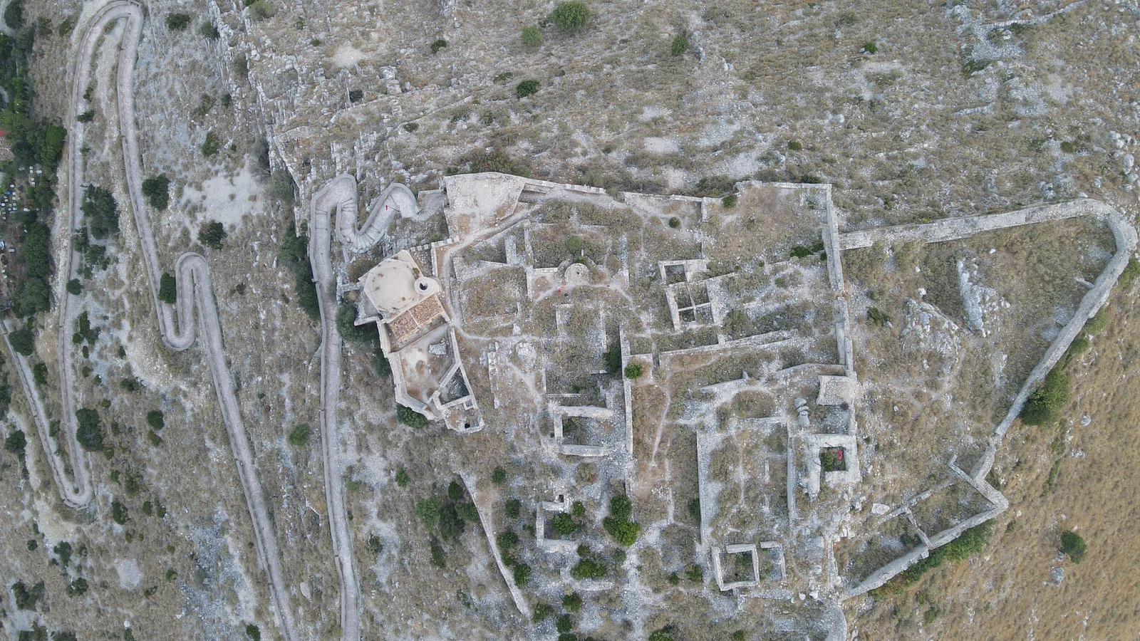
Published plans distinguish the ancient acropolis from the smaller medieval castle. Wall heights, buildings, terraces and paths remain proposals; the drone photographs are not a surveyed terrain model.
The hill above modern Borsh commanded the coastal route and a branch leading inland along the Çorraj valley. The ancient name of the settlement is uncertain: Borsh is the modern place-name used for this reconstruction.
Jano Koçi’s 1977 study distinguishes the acropolis, the lower city and a further ancient extension. He records an acropolis of about 1.2 hectares, with a wall circuit of about 500 metres, extending towards a northeastern crest and rectangular tower. The acropolis must not be reduced to the outline of the smaller medieval castle seen in today’s photographs.
The separate Ancient Borsh study proposes a 4th–2nd-century BCE interpretation. The site had earlier occupation and a long later history; that ancient study does not represent every period simultaneously. The published plan and project drone photographs guide the hilltop relationships. They do not establish a metrically registered survey: reconstructed levels, paths, complete wall heights and individual building positions remain interpretations.
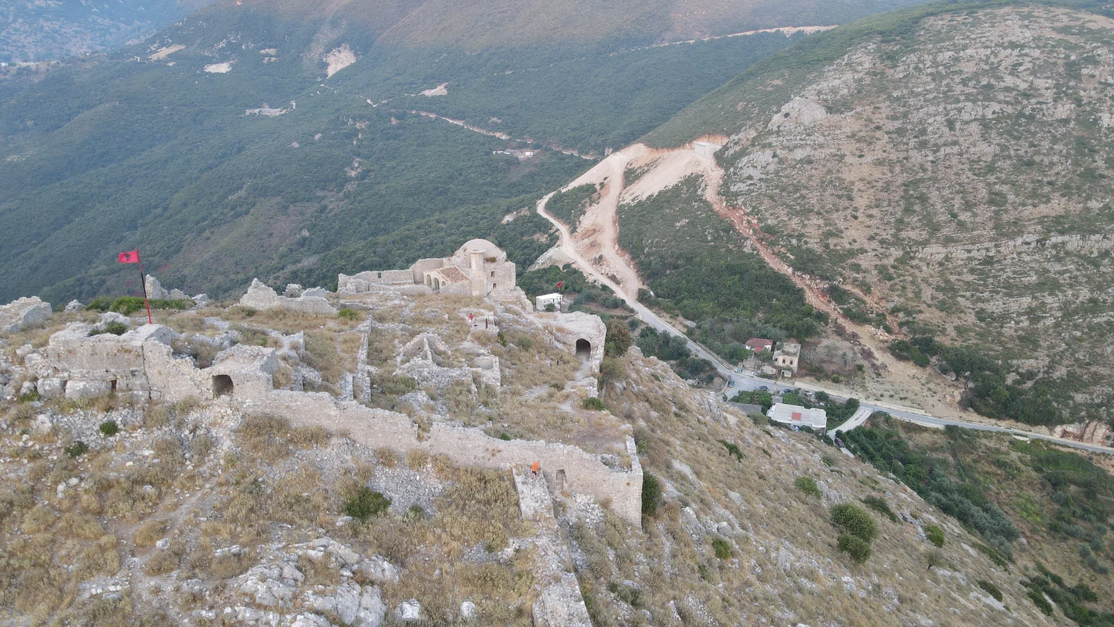
Current ruins include medieval/Ottoman fabric; this is not a photograph of the ancient reconstruction. · Photographs supplied by the project owner; camera metadata records DJI FC3170.02
The ancient walls
Source-informed interpretation · Ancient fortifications · successive phases from the 4th century BCE
The surviving trapezoidal and rectangular masonry informs the wall treatment. The complete circuit, upper courses and defensive crest are reconstructed interpretations, not a stone-by-stone survey.
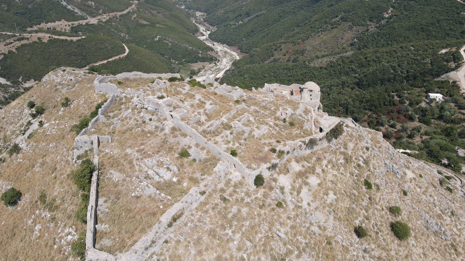
The ancient defences use the hill’s ridges and exposed rock. Koçi reports a well-preserved southwestern stretch 60 metres long, surviving to a maximum height of 4 metres. Those are dimensions of the surviving section, not proof of the original height of every wall.
Much of the circuit used bulging-faced trapezoidal blocks in irregularly interrupted horizontal courses, recorded at 0.30–0.70 metres high. A later ancient extension used more regular rectangular masonry, with courses around 0.50 metres high. These distinct treatments guide the reconstruction; repeated blocks in the model are authored approximations rather than a catalogue of surveyed stones.
Koçi gives 2.5 hectares for the city together with the acropolis, and approximately 3 hectares including its extension. The approximately 1,000-metre wall length belongs to his description of the ancient city circuit. These archaeological totals are distinct from the extent of the medieval fortress and from any measured area claimed for this draft model.
The publication proposes successive construction phases from the 4th century BCE, followed by expansion and repairs. Complete upper courses, defensive crest, missing stretches and terrain contacts remain proposed. The ancient lower city’s angular wall line should not be understood as a ring of medieval towers.
Current ruins include medieval/Ottoman fabric; this is not a photograph of the ancient reconstruction. · Photographs supplied by the project owner; camera metadata records DJI FC3170.03
The earlier keep
Source-informed interpretation · Proposed 12th century · date uncertain
The surviving tower and published dimensions guide the footprint. Its proposed twelfth-century date is not securely established; upper floors, battlements and elevated eastern access are interpretations. The undated later north doorway is omitted.
The square keep belongs to an earlier medieval occupation of the summit. The enclosing castle was built around it later. Nevila Molla discusses a possible twelfth-century context, but the tower has no secure direct construction date. Historical references, including the events of 1258, help frame the debate; they are not a dated foundation inscription.
Molla records an exterior measuring 6.11 × 6.32 m, walls about 1.40 m thick, and a later northern doorway about 0.80 m wide. These later published measurements guide this reconstruction. Karaiskaj’s earlier account gives slightly different measurements, including walls around 1.50 m and a doorway around 0.85 m. The discrepancy is retained as a source limitation rather than treated as proof of centimetre-level certainty.
The northern doorway was opened after the enclosing castle was built, but its date within that later sequence is not secure. It is therefore omitted from this view. The elevated eastern doorway and timber stair are proposed access arrangements, not surviving measured features.
The surviving masonry supports the tower’s presence and plan. Its complete height, timber floors, flat upper platform and battlements require interpretation. Read the restored superstructure as a proposal, not as a complete excavated medieval building.
The separate Medieval Sopot study presents a proposed later thirteenth–fourteenth-century castle setting containing the older keep. The ancient Borsh reconstruction remains a separate experience; its notes explain the earlier city.
Source-informed interpretation · Ancient lower-city entrance · Hellenistic interpretation
Koçi documents an eastern entrance with a corridor parallel to the wall. Its restored width, height, doors and approach are proposed. This is distinct from the later castle entrance.
On the eastern side, Koçi identifies an entrance at point F of the published plan. The passage runs parallel to the wall, giving this approach a different form from a simple opening through the face of the defences.
The same study separately locates the acropolis entrance at the position later used by the medieval castle. It also describes a stepped entrance protected by a small tower in the ancient extension. These are distinct features; the modeled eastern gate does not reproduce the surviving medieval entrance or combine all three into a single gateway.
The source establishes the eastern gate’s corridor arrangement but supplies no measured passage width used here. Its restored width, lintel or roof treatment, doors, complete wall heights and approach path are proposed to make the documented arrangement intelligible and explorable. The current terrain and photographs cannot independently recover all these lost details.
Source-informed interpretation · Terraced houses · Hellenistic phases; later reuse kept separate
Excavation reports supply house dimensions, rock-cut steps and evidence for tiled roofs. The modeled arrangement, repeated houses, complete walls, roof pitches and street layout are proposals, not an excavated city plan.
Borsh’s houses adapted to the steep southwestern and eastern slopes. Excavation reports describe rock-cut floors and wall faces, stone retaining terraces, compacted clay floors and tiled roofs. These source-specific features guide the housing instead of a regular, flat street grid.
Koçi’s 1986 report records an upper part of a two-level house measuring 13 × 4.30 metres, reached by five rock-cut steps. A corridor served rooms to the east. The northern rock face rose 2.20 metres, with a ledge interpreted as support for roof beams. Large worked stones and smaller mud-bonded partition stones had different structural roles.
The 1989 report describes a 1.50 × 10-metre veranda with stone supports at 5-metre intervals. It also records a separate eastern room measuring 5 × 4 metres, with 0.70-metre walls, a 0.80-metre southern doorway and a natural rock face up to 3 metres high. These measurements describe particular excavated structures, not every house in the city.
The model uses the reports as dimensional and construction references. House locations, repeated examples, complete storeys, roofs, furnishings, terraces and connecting paths remain proposed. The medieval lime plaster and bench described in the reused eastern room are kept out of this ancient interpretation. Tiles support a tiled-roof reconstruction, but exact roof pitches and timber joints are not recovered evidence.
Source-informed interpretation · 13th century · proposed phase
Karaiskaj records an internal width of 4.50 m, a projection of about 4 m and paired stair access. The medieval interpretation keeps the tower open inward; a later rear doorway does not measure its wall thickness.
A square tower strengthened the northern side of the medieval enclosure. Karaiskaj records an internal width of 4.50 m and an outward projection of about 4 m. The tower was originally open toward the castle interior, rather than closed as an independent room on every side.
The published description includes two opposed stairways sharing a lower landing: one flight led toward the tower and the other toward the curtain wall-walk. They support the interpretation of connected defensive access. The reconstructed upper masonry, timber surfaces and complete defensive silhouette remain proposals where the surviving fabric is incomplete.
The later rear closure included a doorway about 0.55 m wide. That number describes an opening, not a measured medieval wall thickness. This study keeps the earlier open-backed arrangement distinct from that later alteration.
The thirteenth-century enclosure provides the proposed setting for the tower. Northern repairs are discussed separately in the curtain-wall notes, so the completed model should not be read as a single securely dated building campaign.
Proposed reconstruction · Communal water storage · proposed ancient interpretation
The literature describes communal water storage but provides no measured tank plan or location used by this model. This cistern's position, dimensions, lining and cover are wholly proposed.
Water storage was essential for a settlement on a steep fortified hill. Kriledjan Çipa’s discussion of Borsh’s domestic architecture describes communal public water tanks, contrasting them with the individual wells or tanks known in houses at other sites.
That statement does not supply a plan, dimensions, exact location or detailed construction method for the cistern shown in this scene. Its entire modeled form and placement are proposed. The lining, walls, cover and access illustrate a possible shared water-storage installation; they do not reproduce a verified excavated monument.
The cistern is therefore labelled as a proposed interpretation, with lower confidence than the surviving fortification masonry or the measured house examples. It should not be used as evidence for the ancient city’s exact water network or capacity.
Proposed reconstruction · 13th century · proposed reconstruction
The surviving western side anchors the tower interpretation. Its completed plan, height and defensive upper work carry greater uncertainty than the better documented northern tower.
The medieval enclosure also had a tower on its southern side. Karaiskaj identifies only its western side as surviving medieval fabric. This is a much narrower basis for reconstruction than the fuller description of the northern tower.
The model therefore treats the south tower’s completed footprint, missing walls, upper platform and parapet as proposed. Its relationship to the curtain explains a defensive position, but the missing parts are not represented as a complete measured ruin.
Present-day crenellations on the southern castle walls cannot simply be copied into a medieval reconstruction. Karaiskaj attributes surviving southern battlements to work during the First World War. They document a much later use of the same hill. Any medieval battlements shown here are interpretive replacements, not a claim that today’s profile is medieval.
Source-informed interpretation · Monumental tomb · proposed after the mid-3rd century BCE
The outer footprint and chamber follow Koçi's measured tomb. Placement south of the walls is approximate; complete masonry, covering and stair geometry remain interpreted. The published stair dimensions do not fully agree.
Jano Koçi’s necropolis study records a monumental tomb on the southern slope, 30 metres below the enclosing wall, beside a route towards the city. Its outer construction measured 9.40 × 6 metres and was cut into the ground on three sides. The model follows the published dimensional reference, but its placement against the reconstructed city is approximate, not a surveyed archaeological coordinate.
The entrance lies to the east. A 1.20-metre-wide corridor leads down seven stone steps to the burial chamber, which measures 2.84 × 2.84 metres. The report’s stair dimensions contain a discrepancy: it states seven steps with 0.30-metre treads and rises, but also gives a 1.80-metre stair run and a 0.90-metre landing. The draft retains the documented stair count without claiming all these measurements form a resolved construction drawing.
Koçi proposes a date after the middle of the 3rd century BCE through architectural comparison. The reconstruction’s complete upper masonry, covering and landscape setting remain interpretations. The study also records simple graves from different periods; it does not justify treating every burial outside the walls as Hellenistic or repeating this monumental design across the cemetery.
Published wall positions and thicknesses guide the enclosure. Surviving heights are not complete original heights; parapets, missing wall-walk sections and the surrounding ground remain interpretations.
Medieval Sopot occupied a smaller fortified area at the summit of the hill. Molla describes the principal enclosure as about 0.4 hectares, with the earlier square keep inside. This medieval castle must be distinguished from the much larger ancient acropolis and lower city reconstructed in the separate Ancient Borsh study.
The principal enclosure is assigned to the thirteenth century. The northern masonry also records a later repair discussed in a late thirteenth–fourteenth-century context. The separate Medieval Sopot study adopts that later medieval setting as a proposal; it does not claim that every wall was first built at the same date.
Karaiskaj records curtain thicknesses of about 1.10 m on the west and 1.30 m on the north, with parts surviving to 3–4 m. Those are measurements of particular surviving stretches. They do not establish a uniform complete height around the castle. Stairs and the towers help interpret circulation along the defensive level, while missing wall-walks, parapets and upper masonry require reconstruction.
Interior remains have not all received secure phase assignments. The separate Medieval Sopot study does not populate the enclosure with an assumed medieval village or transfer later cisterns, vaulted rooms and the Ottoman mosque into its medieval setting. Those later elements are distinguished by their labels in the across-time composite. The ground surface and paths are authored interpretations fitted to the proposed reconstruction, not a surveyed medieval terrain model.
Surviving evidence · Later Sopot · medieval and Ottoman history; contextual note
The present castle and mosque belong to later periods visible in the drone photographs. This point explains that history; their complete buildings are not inserted into the ancient city.
The modern drone photographs show a hill changed by many centuries of reuse. The standing castle walls and domed mosque are not a complete surviving image of the Hellenistic city. Their medieval and Ottoman phases require a separate reading.
Nevila Molla’s archaeological study discusses Sopot’s medieval and Ottoman development. Written references place Sopot in the 13th century, and the fortress underwent several later alterations. Its smaller summit enclosures must not be confused with the larger ancient acropolis and lower city described by Koçi.
This marker is a historical context point. The separate Ancient Borsh study follows the proposed 4th–2nd-century BCE setting. The earlier castle is explored in Medieval Sopot, while Borsh across time brings ancient, medieval and Ottoman structures together with their periods identified. The images help identify the hill and surviving remains; the composite does not claim that buildings from different dates all stood together in antiquity.
Current ruins include medieval/Ottoman fabric; this is not a photograph of the ancient reconstruction. · Photographs supplied by the project owner; camera metadata records DJI FC3170.12
The 5 × 4 m room, 0.70 m walls, 0.80 m south door and medieval bench/plaster follow the report. Treating 5 × 4 m as clear interior dimensions is an inference; location and roof are proposed. Pottery does not establish exact coexistence with every fortress phase.
Excavations reported by Jano Koçi identified medieval reuse of the eastern of the excavated rooms, near the foot of the earlier city circuit. The room measured 5 × 4 m, with walls 0.70 m thick, a 0.80 m doorway on the south, and a rock face rising to about 3 m on the uphill side.
The report does not state whether 5 × 4 m are internal or external dimensions. This model treats them as the clear interior, making the outside approximately 6.40 × 5.40 m after adding the reported wall thickness. That dimensional convention is an explicit inference.
The medieval occupation added a stone bench against the northern side, about 0.50 m wide and 0.50 m high. Lime plaster covered the walls and the rock face. These features belong to the later reuse; they are not treated as original Hellenistic fittings.
Glazed pottery indicates early medieval activity and use during the fourteenth–fifteenth centuries. The dwelling shown here is a proposed fourteenth-century interpretation within that wider evidence. The finds do not establish an exact date for every rebuilding or prove that all details of the castle and house stood together at one moment.
One reconstructed dwelling is placed on an interpreted terrace outside the compact summit fortress. Its location within this model, full wall height, pitched roof, timberwork and interior fittings beyond the reported bench/plaster are proposed. The measured room and evidence of reuse support this building type; they do not document a complete medieval village.
Source-informed interpretation · Ottoman context · construction/rebuilding date disputed
The surviving mosque guides the building. Its chronology is disputed, and the complete roof, timber portico and missing finishes are interpretations. Traces of painted decoration survive in the dome and on the walls (2024 photographs). Inside, the dome is first shown as photographed in 2024, with its losses; the wall painting is not mapped onto the model. A button in the 3D view switches to an AI-assisted restoration, which is an interpretation, not a documented original.
The mosque near the fortress entrance is documented in architectural studies and the modern restoration brief. It belongs in this view of Borsh across time, alongside structures from much earlier periods.
Its date needs care. The 2021 Albanian Development Fund brief tentatively places it in the last quarter of the seventeenth century. Gjergj Karaiskaj’s 1986 account instead describes the mosque as built at the beginning of the twentieth century. These statements cannot be combined into a secure original construction date. The label therefore identifies its Ottoman context while keeping the construction or rebuilding chronology disputed.
The restoration brief reports 8.05 × 8.12 m. An on-site masonry study published by Ortega and colleagues in 2026 corroborates an approximately 8 × 8 m exterior, with walls 0.90–0.95 m thick, a dome about 7 m in diameter supported on four squinches, and a northern portico extending across the facade, 2.6 m deep and 4 m high. These are source-specific guides to the building. A separate restoration-brief entry gives 94 m² and 7.8 m; it is not treated as a consistent alternative plan.
The northern doorway, masonry shell, dome system and masonry portico supports are documented. The complete dome surface, proposed timber-and-tile portico roof, missing finishes and details not fixed by these measurements remain interpretations. The reconstructed upper minaret, including its height and finish, is also proposed. The engineering paper’s probable seventeenth-century background date does not resolve the chronological disagreement.
Painted decoration survives inside. Ortega and colleagues record coloured frescoes with geometric patterns that are still partially preserved, and the restoration brief lists the interior’s Muslim frescoes and nakkaşlık (Ottoman ornamental painting) as endangered, proposing to restore the frescoes inside the dome. Photographs taken in August 2024 show what remains: a sunburst medallion at the crown of the dome, rope-twist bands dividing the dome into fields, a pink ring at its base, white and red arch outlines with salmon-pink fields in the zone below the dome, and a pink band along the walls. No source dates this painting, and no inscription is visible. In May 2026 Albania’s Ministry of Tourism, Culture and Sport reported that the mural paintings are being restored, so their present appearance may differ.
Inside the mosque, a button in the 3D view switches the painting between two states. Original, shown first, is the painting as it survives in those 2024 photographs: the dome photograph is mapped onto the model’s dome with its losses, cracks and fading kept, and a stretch of the wall band north of the west window comes from the wall photograph. Where a photograph cannot be placed on the model, including the zone below the dome, whose modeled arches spring about a metre higher than the real ones, the model’s plain plaster is shown instead of invented paint; the two holes in the dome appear as bare masonry because the model’s dome is closed. AI restored is an AI-assisted restoration informed by the same photographs, not a documented original scheme. About half of the dome’s plaster has been lost. The eight-fold layout, the completed fields, the grey-blue brush fans repeated in every field (faint in one field of the photographs, shown at half strength), the centre of the medallion and the fresh colours are interpretations, and the painted wall arches follow the model’s simplified zone below the dome rather than the building’s actual arcade.
The reconstructed mosque does not imply that the ancient houses, medieval keep and this later building all stood in their modeled forms at one date.
Proposed reconstruction · Medieval analogy · local presence and date unconfirmed
No excavated church plan or secure local date underlies this building. Its presence, position, dimensions and complete architecture are proposed; a regional analogy cannot prove a church existed here.
The chapel is included as an explicitly proposed medieval architectural possibility in this composite view. It is not an identified archaeological church at Borsh. The local sources reviewed for this reconstruction do not establish a church plan, dedication, construction date or precise site here.
Sopot’s medieval and Byzantine history is documented, but a settlement’s political or cultural context does not by itself establish the presence or form of a particular church. A comparison with regional church architecture can guide an illustrative design; it cannot supply missing local evidence.
The regional comparison is Church 11 at Palavli, near Kamenicë and Delvinë, published by Ristani and colleagues. It has a single nave, semicircular apse and simple synthronon, with walls 0.65–0.70 m thick. Its precise date is unknown. This provides a medieval architectural comparison, not a securely dated Byzantine prototype or evidence for a Borsh church. The modeled nave is approximately 5.5 × 8 m, with an apse of about 1.5 m radius: these proportions are approximate readings of the comparison plan’s 2 m scale, not printed dimensions or measurements at Borsh.
The chapel’s placement, dimensions, walls, openings, roof and interior are therefore proposals. No excavated pavement, mosaic or painted decoration is claimed. Its label deliberately keeps the local presence and date unconfirmed.
The ancient Borsh and medieval Sopot studies remain available as separate reconstructions. This added hypothesis belongs to the annotated across-time view, where different eras and levels of evidence are shown together.
Proposed reconstruction · Later fortress occupation · individual date uncertain
The published plan guides the footprint. The individual date and use are not securely established; completed walls, doors, roofs and interior arrangements are proposed.
Karaiskaj records that Haxhi Bedu held Borsh in 1769 and began creating a neighborhood within the fortress. This historical account supports later domestic occupation. It does not identify the foundation date of every surviving room.
The architectural description notes houses with barrel-vaulted rainwater cisterns at ground level and one or more rooms. It does not give a complete measured inventory, a secure count of houses or a date for each building. The repeated houses in the model illustrate this documented occupation through proposed examples.
Their individual positions, full dimensions, wall heights, internal divisions, stairways, roofs and furnishings remain interpretive unless a particular source measurement is identified in the reconstruction record. Similar forms do not establish that the houses were all built at once.
The model keeps these later domestic examples distinct in their labels from the source-dimensioned ancient house types and the separately documented medieval terrace dwelling. Their presence together is a way to explore change across time, not a claim of coexistence in a single year.
Proposed reconstruction · Later fortress occupation · individual date uncertain
Its footprint is recorded. A ground-floor cistern with a room above follows a generally attested later house type, but assigning that function here, the three modeled vaults, stairs and complete upper room are proposals. The individual date is uncertain.
Karaiskaj’s account describes later fortress houses as generally having ground-floor rainwater cisterns covered by barrel vaults, with one or more rooms associated with the dwelling. This is evidence for a building type, not a measured schedule of every cistern in the fortress.
The Albanian culture ministry’s restoration update of 4 May 2026 reports the uncovering of rainwater cisterns at Borsh. It supports their survival and investigation; it does not by itself provide a date, volume or reconstruction drawing for the cistern shown here.
The model illustrates rainwater storage during the later occupation. Its dimensions, capacity, water level, completed vault, waterproof lining and access details remain proposed wherever no specific measurement is cited. These later domestic cisterns are distinct from the interpreted communal waterpoint in the ancient Borsh study.
Source-informed interpretation · Later fortress phase · gate inscription 1918
The source reports a later barrel-vaulted corridor 10.65 m long. Photographs guide the rectangular pilasters, recessed panels, stepped caps and arch stones. The visible inscription reads 1918; it does not date the entire passage. Exact ornamental proportions, clear width, completed vault and joining ground remain interpretations.
Karaiskaj describes the fortress’s later principal entrance as a 10.65 m long barrel-vaulted corridor. This is the eastern/southeastern entrance. The source does not establish its clear width, complete height or every detail of the reconstructed vault. The model’s width and completed profile are interpretive.
A different, later opening was cut through the western dividing wall. Its vaulted chamber measures 2.65 × 4 m, with walls about 0.70 m thick. The 4 m is a length, not a height. A possible house above this passage is an inference; it does not establish a securely dated medieval upper room.
These two entrances are kept distinct in the model and labels. The later eastern corridor replaces the earlier eastern-entry interpretation in this composite view. The earlier entrance remains available in the separate medieval Sopot study. Full elevations, doorway finishes, vault completion and adjoining ground remain proposals.
The outer eastern portal now follows the photographed rectangular engaged pilasters, rough recessed panels with rounded lower ends, narrow pale frames and layered projecting caps. These details follow the 2015 entrance photograph by Silvitriana and later views. The 2022 CHwB Albania archive photograph records the inscription 1918 above the arch. That inscription does not date the complete passage or establish medieval ornament. Exact carved profiles and proportions remain photo-informed interpretations within the existing opening.
Proposed reconstruction · Later fortress occupation · individual date uncertain
Only a limited reconstruction of the recorded remains is shown. Individual phase, full height, roof and function are unconfirmed; any storage or domestic interpretation is hypothetical.
Molla’s published castle plan records a longer incomplete outline in the northwest and a compartmented group farther south. These traces guide the limited remains shown here. They are not evidence for complete buildings with securely known elevations and functions.
The model retains their uncertain status. The dates of the individual walls, original full height, roof form and exact uses have not been established. A small compartment could suggest storage, water management or domestic activity, but its shape alone cannot decide between those functions.
Karaiskaj’s description of later houses and vaulted cisterns provides broader context. It cannot turn every room on the plan into an identified house or cistern. Any partial completion or storage interpretation in this view is therefore explicitly hypothetical.
Source-informed interpretation · Ottoman extension · proposed phase around 1571–72
The western addition is recorded at approximately 0.13 ha. Its phase attribution, restored upper defenses, access and surrounding terrain should not be mistaken for a single fully surveyed historical state.
The later western enclosure adds about 0.13 ha to the principal fortress of approximately 0.4 ha. These compact inner areas are distinct from the much larger ancient city circuit. The published figures are approximate, and Karaiskaj’s summary gives a slightly different main-fortress area.
Karaiskaj associates the western addition and a southern wall phase with works around 1571–72. Further southward changes and repairs belong to the second half of the eighteenth century. The composite presents the site’s development without claiming that every restored feature belongs to one construction campaign.
The western wall is reported as approximately 1.60 m thick, surviving almost to its roughly 5 m height, with an upper parapet, crenellations and a wall-walk about 1 m wide. The recorded remnant provides useful construction evidence. Missing wall sections, complete upper defenses, access details and the terrain of the model remain interpretations.
This Ottoman addition is deliberately absent from the separate medieval Sopot study, which explores the earlier fortress before these later changes.
Explore Borsh across its ancient, medieval and Ottoman history. This composite brings structures from different eras together, with each building’s period, evidence and reconstruction limits clearly identified.